ਨਿਊ ਹੈਂਪਸ਼ਰ
ਦਿੱਖ
| ਨਿਊ ਹੈਂਪਸ਼ਰ ਦਾ ਰਾਜ State of New Hampshire | |||||
| |||||
| ਉੱਪ-ਨਾਂ: ਗ੍ਰੇਨਾਈਟ ਰਾਜ | |||||
| ਮਾਟੋ: Live Free or Die ਅਜ਼ਾਦ ਜੀਓ ਜਾਂ ਮਰ ਜਾਓ | |||||
 | |||||
| ਦਫ਼ਤਰੀ ਭਾਸ਼ਾਵਾਂ | ਅੰਗਰੇਜ਼ੀ | ||||
| ਵਸਨੀਕੀ ਨਾਂ | ਗ੍ਰੇਨਾਈਟ ਰਾਜਵਾਸੀ, ਨਿਊ ਹੈਂਪਸ਼ਰੀ | ||||
| ਰਾਜਧਾਨੀ | ਕਾਂਕੋਡ | ||||
| ਸਭ ਤੋਂ ਵੱਡਾ ਸ਼ਹਿਰ | ਮੈਨਚੈਸਟਰ | ||||
| ਸਭ ਤੋਂ ਵੱਡਾ ਮਹਾਂਨਗਰੀ ਇਲਾਕਾ | ਵਡੇਰਾ ਮੈਨਚੈਸਟਰ | ||||
| ਰਕਬਾ | ਸੰਯੁਕਤ ਰਾਜ ਵਿੱਚ 46ਵਾਂ ਦਰਜਾ | ||||
| - ਕੁੱਲ | 9,304 sq mi (24,217 ਕਿ.ਮੀ.੨) | ||||
| - ਚੁੜਾਈ | 68 ਮੀਲ (110 ਕਿ.ਮੀ.) | ||||
| - ਲੰਬਾਈ | 190 ਮੀਲ (305 ਕਿ.ਮੀ.) | ||||
| - % ਪਾਣੀ | 4.1 | ||||
| - ਵਿਥਕਾਰ | 42° 42′ N to 45° 18′ N | ||||
| - ਲੰਬਕਾਰ | 70° 36′ W to 72° 33′ W | ||||
| ਅਬਾਦੀ | ਸੰਯੁਕਤ ਰਾਜ ਵਿੱਚ 42ਵਾਂ ਦਰਜਾ | ||||
| - ਕੁੱਲ | 1,320,718 (2012 ਦਾ ਅੰਦਾਜ਼ਾ)[1] | ||||
| - ਘਣਤਾ | 147/sq mi (56.8/km2) ਸੰਯੁਕਤ ਰਾਜ ਵਿੱਚ 21ਵਾਂ ਦਰਜਾ | ||||
| - ਮੱਧਵਰਤੀ ਘਰੇਲੂ ਆਮਦਨ | $60,441 (6ਵਾਂ) | ||||
| ਉਚਾਈ | |||||
| - ਸਭ ਤੋਂ ਉੱਚੀ ਥਾਂ | ਮਾਊਂਟ ਵਾਸ਼ਿੰਗਟਨ[2][3][4][5] 6,288 ft (1916.66 m) | ||||
| - ਔਸਤ | 1,000 ft (300 m) | ||||
| - ਸਭ ਤੋਂ ਨੀਵੀਂ ਥਾਂ | ਅੰਧ ਮਹਾਂਸਾਗਰ[3] sea level | ||||
| ਸੰਘ ਵਿੱਚ ਪ੍ਰਵੇਸ਼ | 21 ਜੂਨ 1788 (9ਵਾਂ) | ||||
| ਰਾਜਪਾਲ | ਮੈਗੀ ਹਸਨ (ਲੋ) | ||||
| ਸੈਨੇਟ ਦਾ ਮੁਖੀ | ਪੀਟਰ ਬ੍ਰੈਗਡਨ (R)[6] | ||||
| ਵਿਧਾਨ ਸਭਾ | ਸਧਾਰਨ ਕੋਰਟ | ||||
| - ਉਤਲਾ ਸਦਨ | ਸੈਨੇਟ | ||||
| - ਹੇਠਲਾ ਸਦਨ | ਪ੍ਰਤੀਨਿਧੀਆਂ ਦਾ ਸਦਨ | ||||
| ਸੰਯੁਕਤ ਰਾਜ ਸੈਨੇਟਰ | ਜੀਨ ਸ਼ਾਹੀਨ (ਲੋ) ਕੈਲੀ ਏਯੋਟ (ਗ) | ||||
| ਸੰਯੁਕਤ ਰਾਜ ਸਦਨ ਵਫ਼ਦ | 1: ਕੈਰਲ ਸ਼ੀਆ-ਪੋਰਟਰ (ਲੋ) 2: ਐੱਨ ਮੈਕਲੇਨ ਕਸਟਰ (ਲੋ) (list) | ||||
| ਸਮਾਂ ਜੋਨ | ਪੂਰਬੀ: UTC-5/-4 | ||||
| ਛੋਟੇ ਰੂਪ | NH N.H. US-NH | ||||
| ਵੈੱਬਸਾਈਟ | www | ||||
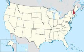
ਨਿਊ ਹੈਂਪਸ਼ਰ (/nuːˈhæmpʃər/ (![]() ਸੁਣੋ)) ਸੰਯੁਕਤ ਰਾਜ ਦੇ ਉੱਤਰ-ਪੂਰਬੀ ਹਿੱਸੇ ਦੇ ਨਿਊ ਇੰਗਲੈਂਡ ਖੇਤਰ ਵਿੱਚ ਸਥਿਤ ਇੱਕ ਰਾਜ ਹੈ। ਇਸ ਦਾ ਨਾਂ ਦੱਖਣੀ ਇੰਗਲੈਂਡ ਦੀ ਹੈਂਪਸ਼ਾਇਰ ਕਾਊਂਟੀ ਮਗਰੋਂ ਰੱਖਿਆ ਗਿਆ ਸੀ। ਇਸ ਦੀਆਂ ਹੱਦਾਂ ਦੱਖਣ ਵੱਲ ਮੈਸਾਚੂਸਟਸ, ਪੱਛਮ ਵੱਲ ਵਰਮਾਂਟ, ਪੂਰਬ ਵੱਲ ਮੇਨ ਅਤੇ ਅੰਧ ਮਹਾਂਸਾਗਰ ਅਤੇ ਉੱਤਰ ਵੱਲ ਕੈਨੇਡੀਆਈ ਸੂਬੇ ਕੇਬੈਕ ਨਾਲ਼ ਲੱਗਦੀਆਂ ਹਨ। ਇਹ ਪੰਜਾਹ ਸੰਯੁਕਤ ਰਾਜਾਂ ਵਿੱਚੋਂ 5ਵਾਂ ਸਭ ਤੋਂ ਛੋਟਾ ਅਤੇ ਨੌਵਾਂ ਸਭ ਤੋਂ ਘੱਟ ਅਬਾਦੀ ਵਾਲਾ ਰਾਜ ਹੈ।
ਸੁਣੋ)) ਸੰਯੁਕਤ ਰਾਜ ਦੇ ਉੱਤਰ-ਪੂਰਬੀ ਹਿੱਸੇ ਦੇ ਨਿਊ ਇੰਗਲੈਂਡ ਖੇਤਰ ਵਿੱਚ ਸਥਿਤ ਇੱਕ ਰਾਜ ਹੈ। ਇਸ ਦਾ ਨਾਂ ਦੱਖਣੀ ਇੰਗਲੈਂਡ ਦੀ ਹੈਂਪਸ਼ਾਇਰ ਕਾਊਂਟੀ ਮਗਰੋਂ ਰੱਖਿਆ ਗਿਆ ਸੀ। ਇਸ ਦੀਆਂ ਹੱਦਾਂ ਦੱਖਣ ਵੱਲ ਮੈਸਾਚੂਸਟਸ, ਪੱਛਮ ਵੱਲ ਵਰਮਾਂਟ, ਪੂਰਬ ਵੱਲ ਮੇਨ ਅਤੇ ਅੰਧ ਮਹਾਂਸਾਗਰ ਅਤੇ ਉੱਤਰ ਵੱਲ ਕੈਨੇਡੀਆਈ ਸੂਬੇ ਕੇਬੈਕ ਨਾਲ਼ ਲੱਗਦੀਆਂ ਹਨ। ਇਹ ਪੰਜਾਹ ਸੰਯੁਕਤ ਰਾਜਾਂ ਵਿੱਚੋਂ 5ਵਾਂ ਸਭ ਤੋਂ ਛੋਟਾ ਅਤੇ ਨੌਵਾਂ ਸਭ ਤੋਂ ਘੱਟ ਅਬਾਦੀ ਵਾਲਾ ਰਾਜ ਹੈ।
ਹਵਾਲੇ
[ਸੋਧੋ]- ↑ "Annual Estimates of the Resident Population for the United States, Regions, States, and Puerto Rico: April 1, 2010 to July 1, 2012" (CSV). 2012 Population Estimates. United States Census Bureau, Population Division. December 2012. Retrieved December 21, 2012.
- ↑ "Mt Wash". NGS data sheet. U.S. National Geodetic Survey. http://www.ngs.noaa.gov/cgi-bin/ds_mark.prl?PidBox=PF0951. Retrieved October 20, 2011.
- ↑ 3.0 3.1 "Elevations and Distances in the United States". United States Geological Survey. 2001. Archived from the original on ਅਕਤੂਬਰ 15, 2011. Retrieved October 24, 2011.
{{cite web}}: Unknown parameter|dead-url=ignored (|url-status=suggested) (help) - ↑ Elevation adjusted to North American Vertical Datum of 1988.
- ↑ The summit of Mount Washington is the highest point on the northeastern Northern American Continent.
- ↑ In the event of a vacancy in the office of Governor, the President of the State Senate is first in line for succession.


